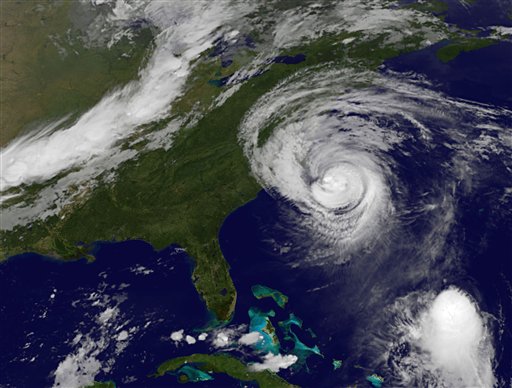

This satellite image provided by NOAA shows Hurricane Earl taken Friday Sept. 3, 2010 at 12:01 a.m. EDT. Hurricane Earl was downgraded to a Category 2 storm with maximum sustained winds near 105 mph. National Weather Service meteorologist Hal Austin said the eye of the hurricane was expected to get as close as 55 miles east of the Outer Banks about 2 a.m. Friday. (AP Photo/NOAA)
Tropical storm warnings remain in effect for Suffolk County and a watch is still in effect for Nassau as the Island braces for the effects of Hurricane Earl.
The storm is now a Category 2 hurricane, with maximum sustained winds up to 105 mph. Earl is moving north northeast at 18 mph and is expected to pass between 100 and 200 miles southeast of Montauk late Friday. According to the National Weather Service, Suffolk County could have winds up to 60 mph.
Forecasters also predict heavy rain, and waves that could be as high as 12 feet.
The National Weather Service expects substantial beach erosion with washovers possible, especially along the south shore.
Beaches throughout Nassau and Suffolk are closed due to the dangerous conditions of the ocean. The beaches in Nassau that are closed are the Village of Atlantic Beach, Long Beach, Nickerson Beach, Point Lookout, Lido Beach, Lido West, Mailbu, East Atlantic Beach, Jones Beach and Tobay.
[popup url=”http://assets.longislandpress.com/photos/gallery.php?gazpart=view&gazimage=6926″] Click here to view more photos of Hurricane Earl[/popup]
Suffolk County Parks have been impacted by the hurricane as well. Cedar Point in East Hampton was closed, as was Theodore Roosevelt in Montauk. The camping section of Blydenburgh park in Smithtown and Southaven in Brookhaven will be closed. Ocean beaches are closed at Smith Point in Shirley, Cupsogue Beach in Westhampton and Shinnecock East in Southampton. Indian Island in Riverhead might be closed Friday.
The Long Island Rail Road has already suspended service east of Speonk and Ronkonkoma. Bay-Shore based Fire Island Ferries will stop running at 3 p.m. Friday. Sayville Ferry Service has canceled services to some communities as well and additional cancellations are likely. Patchogue-based Davis Park Ferry Company has service until 3:20 p.m., with service after to be announced.
PetSafe Coalitiion is opening an emergency shelter at Bideawee Inc., located at 3300 Beltagh Avenue, Wantagh. The shelter will be open Friday afternoon through the duration of the effects of Hurricane Earl. Those interested in volunteering should contact 516-404-5513.
In Suffolk County, shelters may open based on the nature, severity and the number of residents impacted. The Suffolk County Red Cross will open a voluntary pre-storm shelter at the Montauk Playhouse Community Center located at 12 Flamingo Avenue in Montauk. Shelter locations are also available to residents who visit www.SuffolkCountyNY.gov.
Suffolk County police also reminded residents that during severe weather conditions to call 911 only in real emergencies and to call 631-852-COPS to report flooding and downed trees. Any electrical outages can be reported directly to the Long Island Power Authority at 1-800-490-0075.
With the Associated Press and Timothy Bolger


