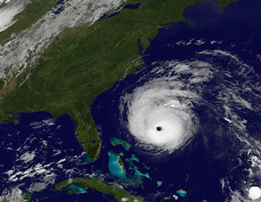

This image provided by NASA shows Hurricane Earl taken at 12:45 a.m. EDT Thursday Sept. 2, 2010. As of Wednesday night, Earl was a powerful Category 4 hurricane centered more than 520 miles south-southeast of Cape Hatteras, N.C., with winds of 140 mph. (AP Photo/NASA)
Hurricane Earl has dropped back down to a Category 3 storm, but as of Thursday afternoon a tropical storm warning is still in effect for Suffolk County, with a tropical storm watch for Nassau County.
The storm’s maximum sustained winds are now 125 mph, and it is moving north at 18 mph. Earl is expected to turn toward the north north-east with an increase in its forward speed on Friday. Hurricane force winds extend 90 miles from the center and are widening, Bill Read, the National Hurricane Center’s director, reported. The storm’s tropical storm force winds extend 230 miles.
[popup url=”http://assets.longislandpress.com/photos/gallery.php?gazpart=view&gazimage=6926″] Click here to view more photos of Hurricane Earl[/popup]
Earl is not expected to make direct landfall on Long Island, but Steven Englebright, the current of geology at Stony Brook University, urged residents to remain alert in case the track changes. “These things are completely unpredictable beasts,” he said.
The National Weather Center predicts that the storm will produce tropical storm conditions with winds between 39 to 73 mph within the next 24 hours from the Fire Island inlet northward and eastward to Port Jefferson harbor. Similar conditions are possible within the next 36 hours west of the Fire Island inlet and Port Jefferson Harbor.
According to forecasts, Long Islanders can expect winds to pick up Friday and 1 to 2 inches of rain could be possible. The storm surge could rise as high as 3 feet and be accompanied by large waves that will cause dangerous surf conditions and rip currents. Beach erosion will likely occur.
Officials on Long Island are preparing for the impending storm. “It doesn’t look like we’re going to be hit very hard, but we have to remain prepared,” said Vivian Viloria-Fisher, a Suffolk County legislator. “There are no evacuations at this time.” Suffolk County Executive Steve Levy has an emergency notification system set up that will send messages directly to homes and businesses. The system has e-mail and text message capabilities
The Long Island Power Authority is bringing in 1,600 out of state line workforce, and an additional 2,000 LIPA workers are prepared to help with customer support and logistics, Chief Operating Officer Mike Herby reported.
Even though the storm is weakening, it still remains a threat to the area, experts warn. “This is the strongest hurricane to threaten the northeast and New England since Hurricane Bob in 1991,” said Dennis Feltgen, a meteorologist and spokesman for the National Hurricane Center. “They don’t get storms this powerful very often.” Hurricane Bob did not make landfall on Long Island but did cause hurricane conditions for eastern Suffolk.
With Associated Press


