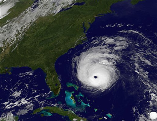

This image provided by NASA shows Hurricane Earl taken at 12:45 a.m. EDT Thursday Sept. 2, 2010. As of Wednesday night, Earl was a powerful Category 4 hurricane centered more than 520 miles south-southeast of Cape Hatteras, N.C., with winds of 140 mph. (AP Photo/NASA)
A tropical storm warning is in effect for Suffolk County as of Thursday morning. Nassau County is currently under a tropical storm watch.
Hurricane Earl is still a Category 4 hurricane, with maximum sustained winds that are now as high as 140 mph, and is moving NNW at 18 mph. The National Hurricane Center is describing the storm as an “intense hurricane,” and parts of coastal North Carolina are being evacuated. Earl is expected to possibly weaken later on today, but is expected to increase its forward speed on Friday. Hurricane force winds are reported to extend 90 miles from the center with tropical storm force winds extending 230 miles.
[popup url=”http://assets.longislandpress.com/photos/gallery.php?gazpart=view&gazimage=6926″] Click here to view more photos of Hurricane Earl[/popup]
“
Earl is expected to reach the North Carolina coast late Thursday and turn to the northeast, staying offshore. However, forecasters warn that it could move in closer, perhaps coming ashore in North Carolina and crossing Long Island.
Forecasters say that the storm is expected to produce tropical storm conditions with winds between 39 to 73 mph within the next 24 hours from the Fire Island inlet northward and eastward to Port Jefferson harbor. Similar conditions are possible within the next 36 hours west of the Fire Island inlet and Port Jefferson Harbor.
Long Islanders can expect winds to pick up Friday, according to forecasts, and the storm surge could rise as high as 3 feet and be accompanied by large waves that will cause dangerous surf conditions and rip currents. The National Weather Center predicts that 1 to 2 inches of rain could be possible in the area, and beach erosion will likely occur.
Officials on Long Island are preparing for the impending storm, and the worst case scenario. “We don’t know exactly which way he will turn, hopefully he’ll stay away, but hope does not replace preparedness,” Sam Kille, a spokesperson for the American Red Cross said.
The Long Island Power Authority is bringing in 1,600 out of state line workforce, and an additional 2,000 LIPA workers are prepared to help with customer support and logistics, Chief Operating Officer Mike Herby reported. Red Cross officials have as many as 50 shelters that they are prepared to open that would be able to house up to 60,000 people if needed.
Suffolk County Executive Steve Levy will re-examine possible evacuation orders Thursday, and has an emergency notification system set up that will send messages directly to homes and businesses.
With Associated Press


