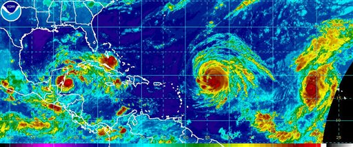

This image provided by NOAA taken at 4:15 a.m. EDT Wednesday Sept. 15, 2010 shows from left Tropical Storm Karl, Hurricane Igor and Hurrican Julia. At 5 a.m. EDT Karl was 105 miles East of Chetumal Mexico with maximum sustained winds of 65 mph. Hurricane Igor was 570 miles East of the Northern Leeward Islands with maximum sustained winds of 145 mph. Hurricane Julia was 525 miles west of the Cape Verde Islands with maximum sustained winds of 135 mph. (AP Photo/NOAA)
Hurricane season is in full bloom for the Atlantic, with a tropical storm that has just made landfall in Mexico and two Category 4 hurricanes still at sea.
Tropical Storm Karl made landfall on Mexico’s Yucatan Peninsula on Wednesday with winds of about 63 to 65 mph, the National Hurricane Center reported. Karl hit a sparsely populated area that is about 30 miles up the coast from Chetumal, the state capital of Quintana Roo.
Forecasters predict that it will weaken into a tropical depression but will strengthen into a hurricane once it returns to the Gulf ‘s waters by the end of the week. Central Mexico’s coast could be threatened.
Hurricane Julia and Hurricane Igor are churning in the Atlantic as well. Julia became a Category 4 storm Wednesday and although Igor’s winds weakened a bit, he is also still a Category 4 storm. As of 11 a.m. both hurricanes currently have maximum sustained winds of 135 mph, according to the National Weather Service.
Neither Julia nor Igor currently pose any threats to land, although meteorologists said that there is a possibility that Igor could hit Bermuda over the weekend. The current expected path for Julia predicts the storm will stay out at sea.
With Associated Press


